|
Armstrong Trail |
one moment while we fetch a trail picture
|
|
|
Armstrong Trail |
one moment while we fetch a trail picture
|
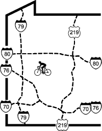
| Location | East Brady to Schenley, Armstrong and Clarion Counties | ||
| Trailheads | Catfish, Bradys Bend, East Brady, Phillipston, Redbank, Rimer, Templeton, | ||
| Length, Surface | 52 miles total (33.0 crushed limestone, 4.0 paved,1.0 on road, | ||
| Character | Uncrowded, mixed urban, rural, and wooded, mixed sun and shade, flat | ||
| Usage restrictions | No horses, no motorized vehicles, no snowmobiles | ||
| Amenities | Rest rooms, water, food, lodging | ||
| Driving time from Pittsburgh | 1 hours 1 minutes |
Some of original stone railroad mileposts remain, though most have been removed. The numbering starts in Pittsburgh at MP 0 and ends in Oil City at MP 130. Mileposts installed by the trail volunteers preserve the original numbering. The developed portion of this trail starts at MP 75.1 and extends southward to MP 38.6.
Although the northern end of the trail is at MP 75.1, there is no trailhead access at this point. The nearest reasonable access is from the East Brady Spur Trail (see page 106)or at Phillipston. Both of which pass by the south end of the Brady Tunnel.
From MP 75.1 to the north end of the Brady Tunnel (MP 71.6) the trail is just above the Allegheny river with a 300 foot hillside on the left.
The tunnel is 2468 feet (.047 miles) long and is lighted with motion sensing lights. Note the mile post at the northern end of the tunnel is 71.6, while the milepost at the southern end of the tunnel is 64.7, a 6.9 mile distance. This is because originally the railroad went around the Brady Bend and when the tunnel was dug the railroad as usual did not move the mileposts.
Just upstream of the south end of the tunnel a sluice box has been restored and carries a creek over the portal of the East Brady tunnel.
On a hot summer day, a cool breeze emanating from the south end of the tunnel announces its location. A bench and an interpretive sign are nearby. The main line of the trail goes through this tunnel and continues to Upper Hillville. From the north end of the tunnel, about 5 miles of trail is finished and open.
Continuing along the Allegheny River from the tunnel a tall cement structure looms over the trail at MP63.7. This was a coal loading tower. Small coal cars from the mine were unloaded in the low building on the left. Coal was conveyed upward and stored in the taller tower on the right. Steam engines would then pass under the tower and have there tenders filled with coal. Just 0.2 miles farther, at MP63.5, the trail splits. The left fork is the beginning of the 51-mile Redbank Valley Trail (page NE-137) that travels up Redbank Ck to Brookville.
The right fork at the split takes the Armstrong Trail on down the Allegheny River. It immediately crosses over Redbank Ck (MP 63.4) to the Redbank Creek Trailhead. From here it enters a long sunny stretch to Lock and Dam #9 (MP 61.6).
The river community of Rimer runs from MP 61.0 to MP 59.4. There is an out-of-the-way trailhead at south end of Rimer.
From Rimer the trail continues besides the river, passing through the grassy hillside of the settlement of Hook Station (MP 57), where a barrier once blocked the trail. Although the lawsuit over access is settled, there may be lingering sensitivity in this area, so please observe trail etiquette (everywhere, of course, but especially here).
The former village of Grays Eddy (MP 55.5) has a historical marker, but no buildings remain. A stone arch bridge passes under the trail here. This shady spot is a pleasant place to rest. After Gray’s Eddy the trail crosses under a railroad bridge (MP 54.9) that serviced a now-closed generating station across the Allegheny River. The trail then crosses the mouth of Mahoning Ck (MP 54.8).
At the Fish and Boat Commission boat ramp in Templeton (MP 53.8) the trail continues past the parking area. Here the trail previously used streets, but construction completed in 2020 eliminated all streets. The trail descends at 3rd St (MP 53.5), and climbs back up again on asphalt.
The trail passes the remains of the Harbison-Walker Brick Plant (MP 53.4), which made firebrick for the steel industry but closed about 1987. All that remains is a long one story shed.
A Little Free Library is beside the trail at MP 52.7 and an adjacent path leads to a shady bench in the woods. This library focuses in children’s books. Feel free to take one or leave one.
Lock and Dam #8 (MP 51.5) offers trail parking at the end of a minor road. From MP 50.8 to MP 49.8 there are occasional houses on the left side of the trail and lots of trailers below the trail on the river side of the trail. The trail crosses a gravel road and Pine Ck at MP 49.7. From MP 49.6 to MP 49.2 the trail is on the edge of a another trailer park. The stone structure at MP 47.9 is the remains of the Monticello Iron Furnace.
At Cowanshannock Junction (MP 47.3), the trail passes the Bernard C. Snyder Picnic area of the Canfield-Holmes Sanctuary and a PA Fish and Boat Commission boat ramp on Cowanshannock Ck. Cowanshannock Trail, a spur trail to Buttermilk Falls, heads up the creek along the edge of the hill behind the parking lot. Immediately after this trailhead, the trail crosses Cowanshannock Ck (MP 47.4).
At Lemon Way (MP 46), the trail enters Kittanning, changing from crushed limestone to asphalt. The trail goes through the middle of Kittanning as a separated path beside the road, principally through residential neighborhoods and a few areas of light industry. There are lots of cross streets, so be careful at each intersection, as drivers may fall to notice activity in the bike lane.
At the south end of town, the trail goes through the parking lot of the King’s Lanes bowling alley (MP 44) and passes under Water St. Just before entering the woods (MP 43.7), a pedestrian/bicycle ramp leads up to the Edgewood Park-and-Ride lot beside old PA66 (now Hill St). Here the trail surface changes from asphalt to crushed limestone, and the trail is delightfully shady and surprisingly isolated along the river for most of a mile.
As the trail passes an electric substation, it goes downhill. Eventually there will be a bridge here to carry the trail across the road and behind the houses on the far side. For now (2022), at the bottom of the ramp, there is a sharp U-turn onto the road towards the river, followed quickly by a turn on to a ramp and then a sharp left turn that leads back up to the railroad grade. This is another area of the trail where courts had to settle trail ownership, so stay on the trail.
After crossing Mckean St the trail is adjacent to a ballfield. It enters Ford City at 17th St, continuing on a berm above the adjacent streets. There are a repair station and a gazebo at 14th St (MP 41.45), and the trail surface turns from crushed limestone to asphalt. This very popular section runs through Ford City’s commercial, industrial, and residential area. The trail is slightly elevated above the street level and has several small gazebos with hexagonal picnic tables. There are rest rooms at 9th St. (MP 40.84)
After crossing PA128 the trail is asphalt for another quarter-mile, to the mouth of Tub Mill Run, where it changes to crushed limestone for the last mile to the PA Fish and Boat Commission boat launch and parking area in Rosston (MP 39.1). Just beyond the parking area the trail crosses Crooked Ck on a recently (2020) refurbished
The section of trail from Crooked Creek to Schenley was un-railbanked i.e. claimed by a ming company and was closed to trail users. The mine has closed and the trail group has reacquired the trail opened it in 2024.
In Schenley the trail passes by the railroad station and the Kiski Junction Railroad engine #7135. 1100 feet after the engine, the connection to the Leechburg Spur is just before crossing the Kiskiminetas River. This Spur trail is about 5 miles and currently ends in Leechburg. Eventually this will connect to Harrisburg.
The Armstrong trail ends just 20 feet from the far end of the Kiski Bridge. This missing piece was because of a transcription error in the recording of the deed transfers. Plans are in place to connect to the Tredway Trail which can be seen from the bridge.
East Brady Spur Trail
In East Brady, the trail begins at Sixth St and Purdum St near MP68. There is limited on-street parking here, so it is best to actually begin either at the East Brady Trailhead a quarter-mile down the trail or across the Allegheny River at the Bradys Bend Boat Launch. From Sixth and Purdum a paved trail runs for a quarter-mile along Rex-Hide Dr. At a ball field, the surface changes to crushed limestone. A short spur trail leads from behind the sewer plant to East Brady Riverfront Park with parking, picnic tables, and a canoe/kayak launch area.
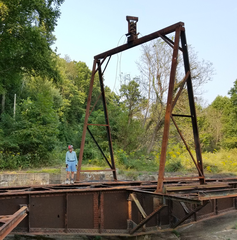
The railroad turntable at Phillipston is being restored
The trailhead parking is on the Vernor St side of the sewer plant. The route from the parking lot to the trail goes uphill to Vernor St and turns right/south on the paved road. Vernor St turns into Shady Shore Dr and then Hidden Trail Rd. Both of the latter are private roads for the homes that lie between the road and the river. The road is open to the public for bicycling and walking, but closed to cars. In this stretch there is about 0.45 miles of asphalt and 0.2 miles of gravel road before the start of the crushed limestone surface.
The crushed limestone surface begins at MP67.2, where the trail splits off from Hidden Valley Trail Rd. This shady trail continues along the bank of the Allegheny River to the small town of Phillipston (MP66.3) where, because of a missing bridge, the trail jogs out to the road and back again. The trail arrives at the Phillipston trailhead parking area (MP65.9) at the south end of town.
The next two and a half miles include three major structural features of the trail.
Just past the gate at the Phillipston parking lot, 100 feet off of the trail, an intact railroad turntable has been cleared of debris and has been restored (MP65.8).There are several picnic shelters with tables here. The stones of a similar turntable can be seen along the Redbank Trail (see page NE-137). A quarter-mile farther (MP65.6), a bench faces a lovely grotto with a waterfall.
Armstrong Trail - Oldest segment segment check 2022-Mar This page brought to you by the book